


Significant differences in meaning on both sides of the Gulf of Guatir/ Mohammad Mohabi
A reflection on the hardships of the Sistan and Baluchestan province.
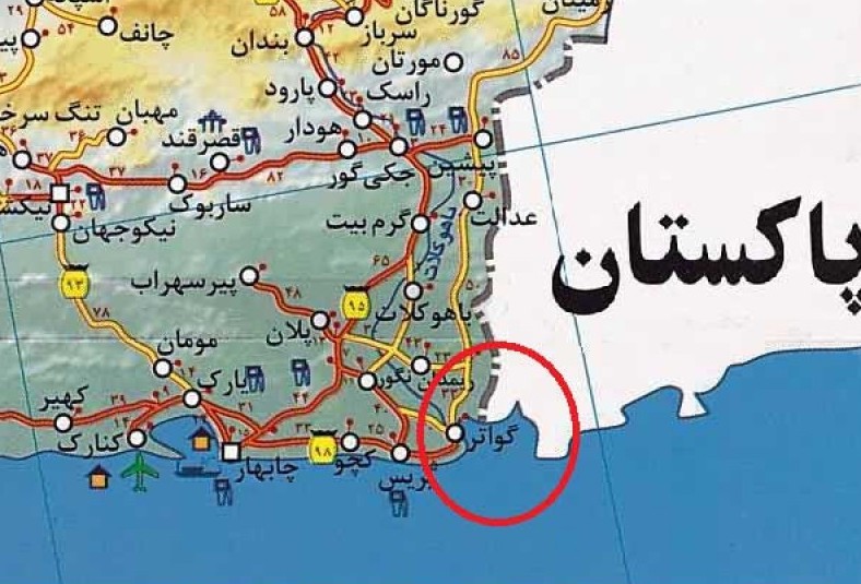
The Gulf of Gwadar is a relatively small gulf in the Arabian Sea, located in the southeastern part of Iran and southwestern part of Pakistan. Half of the gulf is in Iran and the other half is in Pakistan. Due to its proximity to the Tropic of Cancer and its location along the path of monsoon winds, this gulf has a tropical climate.
The villages of Gowater and Pasabandar are located in the Iranian half of this gulf. The inhabitants of these villages are Baloch people with Sunni Hanafi religion, who are mostly engaged in fishing and mat weaving. Gowater has recently received a lot of attention as one of the main centers for shrimp farming and export in Iran. However, the presence of an abandoned English airport in this gulf indicates that this region has also had a prosperous past.
If we move from the Gulf of Guater towards the west, we will reach the port of Chabahar. And if we move from the same gulf towards the east, we will reach the port of Karachi in Pakistan.
Usually, in developed countries, the best and most developed cities are located on the coasts of seas and oceans; because trade has been the most important reason for the establishment of these cities. But in Iran, large and advanced cities are mostly built in the vicinity of deserts or at the foothills of mountains. Perhaps due to the lifestyle of Iranians from ancient times until now, where security has been preferred over trade.
Unfortunately, the most deprived provinces of Iran are located on the southern coast of Iran. The most economically backward province of Iran, Sistan and Baluchestan, has a long coastline on the Sea of Oman. This sea connects to the Indian Ocean and all the world’s open waters. This province was the largest grain storage of Iran until 50 years ago and benefited from the blessings of Lake Hamun, but with the gradual drying up of this lake, it has moved towards backwardness. Meanwhile, the coastline of this province could have provided the basis for economic development. According to official statistics, the unemployment rate in this province is 35%, which is a worrying figure. Additionally, 24% of the total illiterate population of Iran lives in Sistan and Baluchestan province.
Truly, where is the problem? Some attribute the main reason for underdevelopment to the climate and weather of this province. Others believe that because the religion of the majority of people in this province, especially the Balochis, is different from the official religion of the country, the central governments have been indifferent towards the development of this province.
The majority of Baloch people are Sunni Muslims and followers of the Khafi sect. The Masjid and Darul Uloom Makki in Zahedan can be considered the most reputable Sunni religious school in all of Iran, with students from all over Iran, as well as Afghanistan, Pakistan, and Tajikistan studying there. The founder of this great school was the late Mawlana Abdul Aziz Malazadeh, who is still the most beloved Sunni religious leader in Iran. In 1358, he was a representative of the province in the Assembly of Experts and resigned in protest against the approval of Article 12 of the Constitution. He believed that instead of declaring Shia Islam as the official religion, Islam as a whole should be recognized as the official religion and the six schools of thought (Ja’fari, Hanafi, Maliki, Shafi’i, Hanbali, and Zaydi) should be equally recognized. The current director of this school, who is
Despite all the limitations that have been imposed on the people of this province and the numerous insults to their respected figures in official tribunes, radical movements have never taken shape in this province. This is despite the fact that in the past 20 years, some religious figures in the province have suspiciously been murdered. When the case of serial killings was brought up in the late 1970s and early 1980s, some of these individuals were mentioned and their murders were seen as part of the same project. People such as Mullah Abdulmalik Malazadeh (son of the late Mullah Abdulaziz), Mullah Ne’matullah Tohidi, Sheikh Ali Dehvari, Mullah Ibrahim Damani, Mullah Abdulaziz Allahyari (Friday prayer leader of the Sunnis in Birjand who was Baloch), Mullah Musa Karampour (Friday prayer leader of Sheikh Feiz Mosque in Mashhad), Mullah Mohammad Jamshid
The purpose of this writing is not to address the problems of Sistan and Baluchestan, but to address a fundamental issue that if not addressed and solved immediately, can lead to great harm. This problem is the lagging behind of the port of Chabahar from its Pakistani rival. The Pakistani government is currently constructing a massive port on the eastern side of the Gulf of Gwadar, which if completed, can completely overshadow the strategic role of the port of Chabahar. We will now delve into the full details of this matter.
Karachi and Gwadar ports, a threat or an opportunity for Chabahar?
Karachi is the largest city in Pakistan and the capital of Sindh province. This city is located in the southeastern region of Pakistan on the coast of the Arabian Sea and in the northwestern part of the Indus Delta. According to statistics published by the United Nations, the population of Karachi was 12,819,000 in 2014, making it the most populous city in Pakistan and the thirteenth most populous city in the world.
The title of this city is “City of the Leader”, which refers to Muhammad Ali Jinnah, the founder of Pakistan. Karachi is the financial and commercial center and the largest port of Pakistan.
The population of Karachi city, like many other cities in Pakistan, was initially low. However, after being chosen as the capital of Pakistan, its population multiplied several times. The population of this city has grown from around 57,000 people in 1856 AD to over 12.5 million people in 2014. This means that in 152 years, more than 12 million people have been added to the population of this city (mostly due to migration). This city is, in a sense, the economic capital of Pakistan. Despite the fact that the economy of Pakistan is in the transition phase from a backward country to a developing country, this port city is relatively more populated and prosperous compared to other parts of Pakistan.
This is a caption.
A school in Chabahar.
But the port of Gwadar is located in the extreme southwest of Pakistan, on the coast of the Gulf of Gwadar in the Arabian Sea. The distance from this port to the center of the Sindh province, Karachi, is 800 kilometers. Due to the unique weather conditions of the region, which is hot and desert-like, and its distance from the political, economic, and population centers of Pakistan, as well as the restriction of all economic and commercial activities in Pakistan to the large and strategic port of Karachi, the development of Gwadar port was neglected by Pakistani authorities in the past. However, since 1995, the development of this port has received attention due to its deep coasts, but due to lack of financial resources, this issue was postponed until 1999. From 1999, the development of this port was once again put on the agenda, this time in the form of creating a free port similar to China’s free trade zones, and after
The implementation of the Guadar Free Zone project has begun and the estimated cost for its completion is around $1.16 billion in two phases. Building roads, changing the traditional way of life for the local people, establishing a power plant, providing necessary gas, connecting the region to the country’s railway network, and creating equipped ports are among the plans that are being implemented. In the first phase, three large ports with the necessary equipment and a capacity of accommodating 50,000-ton ships will be built. Currently, the related channels, with a length of 5 kilometers, have been dredged by Chinese experts. These ports, each with a length of 200 meters, a 350-meter yard, and a 11.5-meter water intake, will be built within 36 months, and there is also the possibility of operating them sooner. The estimated cost for this phase is around $250 million, of which $198 million will be paid by the Chinese and the rest by the
In the second phase, the creation of 10 ports with two large oil terminals and one container terminal is planned. These facilities will be able to accommodate ships with a capacity of 100,000 tons and 200,000 ton oil tankers. The implementation of these projects will transform the Port of Gwadar into one of the busiest and most important commercial and oil centers in Asia. It is worth noting that Oman has also expressed interest in participating in this project and, according to agreements, the Sultan of Oman will contribute $7 million to the construction and equipping of the power plant in this port. The United States and Germany are also among the other countries investing in this port. The second project is the construction of the Makran Highway, which is one of the complementary projects of the Port of Gwadar. This 800-kilometer highway is being built along the southern coast of Pakistan and will connect the Port of Gwadar to the port of Karachi. The implementation of
The development and equipping of Gwadar port and its transformation into a free trade and industrial zone has now become a symbol of friendship between China and Pakistan. It seems that with the extensive economic cooperation between the two countries, the implementation of joint economic projects and massive Chinese investments in Pakistan, Islamabad will become an economic and commercial ally of Beijing in South and West Asia. Undoubtedly, these collaborations will continue to increase, given China’s growing position in the global economy.
The impact of establishing the Gwadar port on the Chabahar port.
The most visible and important negative impact of this plan is the weakening of the existence of the Chabahar Free Trade Zone in southeastern Iran. Undoubtedly, in the current circumstances, Gwadar is the most important and strongest commercial and economic rival to Chabahar. Despite the fact that the Chabahar Free Trade Zone has been active for almost a decade, it has not been able to achieve much success in trade and transit of goods to and from Afghanistan and Central Asia due to various reasons, including infrastructure problems such as lack of suitable rail, road, and air transportation systems. In the current situation, considering the slow development of the region’s infrastructure due to lack of funding and other specific problems, the prospect of improving the situation in the medium term does not seem very promising. This situation is such that Chabahar, despite its strategic importance, has not yet achieved its true position in the national economy. In these circumstances, and with the presence of a global economic
This important matter, on a larger scale, will also influence the strategic plan of the East axis. The significant advantage and importance of the port of Gwadar compared to Chabahar is its proximity to Karachi and its connection through the Makran highway. Undoubtedly, the proximity and connection of Pakistan’s economic capital to Gwadar is a very important factor in the development and equipping of this port. On the other hand, the establishment of the free port of Gwadar will attract and concentrate many economic and commercial activities of countries in this port, considering the speed of action in the process of development and equipping its communication infrastructure.
One of the requirements for the economic and commercial development of the Persian Gulf region is the existence of a commercial center on the northern shores of the Sea of Oman. Chabahar and Gwadar have the best potential for this important task. Without a doubt, whichever of these two regions can achieve results faster and have access to more facilities and amenities, will be able to attract more economic and commercial activities.
In addition to the above cases, the establishment of military bases and equipping of Pakistani and Chinese naval and air forces near the maritime and land borders of Iran naturally carries its own sensitivities and vulnerabilities.
Chabahar Port, its capacities and reasons for underdevelopment.
Chabahar, located next to the coast of the Sea of Oman, covers an area of 25,000 square kilometers, 130 kilometers of which is land border. This port is formed by five central districts, Kanarak, Plan, Dashtiyari, and Zarabad, with a population of 230,000. It includes three cities, Kanarak, Vengur, and Chabahar, as well as 11 villages and 620 settlements, with 33% of the population living in cities and 66% living in villages.
“این عکس یک منظره زیبا از کوهستان است.”
“This photo is a beautiful landscape of the mountains.”
The flower fields in Chabahar.
The beautiful port of Chabahar, although it may seem at first glance to be a deprived region lacking in tourist attractions and historical background, the reality is that this region has the best coastal area in the country and the most moderate climate in the south. It has the potential for all-around development. The flower fields, beautiful rocky beaches, local mosques, traditional architecture, and the fascinating life of the Baloch people with their camels, fig trees, temples, and abundant historical sites are among the tourist attractions of this beautiful port. On the other hand, Chabahar has the potential to become the main center of transit and the hub of development in the east. The flower-shaped hills, as a rare phenomenon in the world, are located in the northwest of the Chabahar region. Three flower-shaped hills are located in the distance between two valleys of Keir and Tang, 20 kilometers from the village of Keir and on the way to Tang road, and Gal
Following the approval of Clause 19 of the 5-year Economic, Social, and Cultural Development Plan in 1989, the government was allowed to establish up to 3 free trade and industrial zones at the country’s border points. However, prior to this date, initiatives had already been taken in Kish and Qeshm, taking into account the existing infrastructure. In 1990, these two regions were officially designated as free zones, and in the following year, Chabahar also joined the ranks of free zones. As a result, 14,000 hectares of land in the eastern part of the Chabahar Gulf were designated as a free zone.
Choosing this region as a free zone brought about a transformation in its economic and cultural functions, and it became a hub for economic and developmental activities. However, necessary attention was not given to other parts of the region, and the old structure of the city suffers from issues such as sanitation, poverty, lack of piped drinking water, and even deprivation of basic necessities for a medium-sized city.
The relative lack of success of the Chabahar Free Trade-Industrial Zone in attracting investments, both domestic and foreign, is due to various general factors such as lack of infrastructure, absence of basic facilities, inadequate public services, restrictions and lack of transparency and clarity in laws and regulations related to investment in the Chabahar Free Trade Zone. The lack of an appropriate executive organization and strong and effective executive management in the Chabahar Free Trade-Industrial Zone, as well as the negative effects of some of the government’s economic policies and strategies at the national level, which also affect the Chabahar Free Trade Zone, are also contributing factors. The lack of clarity in laws, inflexibility, restrictions, and inefficiency and rigidity of some laws and regulations related to this free trade zone are the second major obstacle to attracting investment. The lack of sufficient guarantees and assurances in laws and regulations to protect property rights against confiscation and nationalization, lack of financial incentives for
To start, it’s already late.
In the presidential election of Khordad 1392 (May/June 2013), the people of Chabahar city voted 95% for Mr. Hassan Rouhani. This is one of the highest rates of votes for reformism in Iran. This shows that despite the many deprivations, the people of this region believe in peaceful means. The majority of the people of this city are Hanafi Sunnis, like the rest of the Baloch regions of Iran. Mawlana Abdulrahman Malazaei, known as “Sarbaz” (soldier), is the Friday prayer leader of the Sunni community in Chabahar and the director and founder of the Society of the Two Holy Mosques in Chabahar. He is one of the benevolent scholars of the region.
As mentioned in the above paragraphs, if the development of Gwadar Port in Pakistan reaches its final stages, Chabahar Port will also lose its current unstable position. Therefore, it requires a national determination and sincere effort to start now, as it is already late.
In these circumstances, it is necessary to take the development and equipping of the Chabahar Free Trade-Industrial Zone seriously by understanding the current and emerging conditions accurately and realistically. The current situation threatens the existence of the Chabahar Free Zone. It is proposed that by utilizing Pakistan’s experience in the Gwadar Free Port, the groundwork for economic activities and participation of economic powers in Chabahar be provided and with special and considerable funding, infrastructure projects such as rail, road, and air transportation systems, as well as equipping the ports of the region, be taken seriously. Chabahar has a greater advantage and is more sensitive in terms of transit of goods to Afghanistan and Central Asia compared to two other free zones. Undoubtedly, if Chabahar had been able to establish its real position in economic and trade interactions in the region over the past decade, Gwadar Port could not have shown itself as a serious competitor. In any case, apart
Sources:
Afshar, Iraj, Sistan and Baluchestan Nameh, Tehran, Ketabdar Publishing, 1390 (2011)
Soltani, Alireza, Development of Gwadar Free Port: Chinese-Pakistani Cooperation and its Effects on Iran, Strategic Report, Center for Strategic Research, 1381.
Arshian, Abouzar, Chabahar, the jewel of the East of the Islamic Republic of Iran, Tehran, Ettehadal Publishing, 1388.
Mohammadi, Naser, Geography of neighboring countries: Pakistan, Tehran, Armed Forces Geographical Organization, 1385.
Mahmoudzahi, Mosi, customs, beliefs and culture of Balochistan, Tehran, Abnous Publishing, 1391.
The first five-year development plan, the website of the Center for Parliamentary Research of the Islamic Consultative Assembly of Iran.
 March 25, 2015
Tags
Bandar Chabahar Chabahar Gulf of Guatir Gwadar Port Karachi Port Magazine number 47 Mohammad Mohabbey Monthly Peace Line Magazine